Florence's Cliffs
|
| |
![OR: South Coast Region, Lane County, Pacific Coast, Cape Perpetua Area, Heceta Head, Panorama of sea cliffs at Heceta Head from its beach; these are adjacent to the Heceta Head Lighthouse. [Ask for #276.501.]](./imgstore/276.501.jpg) Sea stacks at Heceta Head. [Ask for #276.501.] |
|
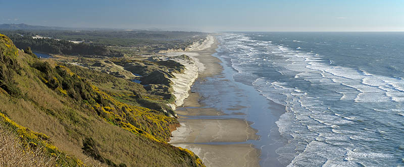
The Cliffs Beyond FlorenceThirteen miles of sea cliffs stretch up the coast from Florence, starting nine miles north of town center. Here the Coast Range plunges straight down into the Pacific, forming cliffs eight hundred feet high. US 101 is cut into a shelf along the entire length, giving frequent stunning views. There are four major sections of these cliffs.
|
![OR: South Coast Region, Lane County, Pacific Coast, Cape Perpetua Area, Cape Perpetua National Scenic Area, Cape Perpetua Overlook, Wood trail sign gives directions for St. Perpetua Trail [Ask for #276.A01.]](./imgstore/276.A01.jpg) The St. Perpetua Trail in the Cape Perpetua National Scenic Area. [Ask for #276.A01.] |
SEA LION CLIFFS |
|
 The northern terminus of the Oregon Dunes, viewed from the cliffs along US 101 just north of Florence. [Ask for 276.570] |
|
![Foot path leads over grassy dunes to the beach. [Ask for 276.461]](./imgstore/276.491.jpg) Foot path leads over grassy dunes to the beach. [Ask for 276.491] |
![OR: South Coast Region, Lane County, Pacific Coast, Oregon Dunes, North of Florence, The northern terminus of the Oregon Dunes, the largest dune field on Oregon's Pacific coast. The dunes impound a small lake. [Ask for #276.484.]](./imgstore/276.484.jpg) The northern terminus of the Oregon Dunes, the largest dune field on Oregon's Pacific coast. The dunes impound a small lake. [Ask for #276.484.] |
![OR: South Coast Region, Lane County, Pacific Coast, Cape Perpetua Area, Sea Lion Cliffs, Cliff view. The Sea Lion Caves attraction is visible in the distance. [Ask for #276.565.]](./imgstore/276.565.jpg) Cliff view towards the Sea Lion Caves attraction. [Ask for #276.565.] |
![OR: South Coast Region, Lane County, Pacific Coast, Cape Perpetua Area, Sea Lion Cliffs, View over the cliffs with gorse in full bloom [Ask for #276.490.]](./imgstore/276.490.jpg) View over the Sea Lion cliffs with gorse in full bloom [Ask for #276.490.] |
HECETA HEAD |
|
![OR: South Coast Region, Lane County, Pacific Coast, Cliffs, Heceta Head, Beach beneath the lighthouse keepers cottage, now a B&B, in fog [Ask for #276.985.]](./imgstore/276.985.jpg) View of Heceta Head and its beach as fog rolls in. [Ask for #276.985.] |
|
|
Built in 1894, the 56 foot tall Heceta (pronounced heh-SEE-tuh) Head Lighthouse sits atop a 200 foot cliff, directly above a white sand beach. Sheer rock cliffs flank the beach and sea stacks rise up from the waters; the cliffs beneath the lighthouse extend into the ocean like so many sharks teeth. It's a state park, accessible from US 101.
US 101 does not, however, run down to the lighthouse or its beach. Instead it plunges through a tunnel then flies right over the beach on a massive arched concrete viaduct. Add in the costs of cutting the highway into the cliffs and you get the "half million dollar mile", in the 1930s one of the most expensive highway projects in America. The turnoff to Heceta Head is on your right as you go up the coast. The access road turns downward, goes under the US 101 bridge, and comes right up to the beach. The lighthouse is a quarter mile walk gently uphill. |
![OR: South Coast Region, Lane County, Pacific Coast, Cape Perpetua Area, Heceta Head, A crow sits on a rock by the beach [Ask for #276.502.]](./imgstore/276.502.jpg) A crow sits on a rock by the Heceta Head beach. [Ask for #276.502.] |
![OR: South Coast Region, Lane County, Pacific Coast, Cape Perpetua Area, Heceta Head, Lighthouse Keepers Cottage, now a B&B, viewed from the beach below [Ask for #276.558.]](./imgstore/276.558.jpg) The lightkeeper's cottage, viewed from the beach below. [Ask for #276.558.] |
![OR: South Coast Region, Lane County, Pacific Coast, Cape Perpetua Area, Heceta Head, View towards the Heceta Head Lighthouse and its cliffs from the beach below [Ask for #276.498.]](./imgstore/276.498.jpg) View towards the Heceta Head Lighthouse and its cliffs from the beach below. [Ask for #276.498.] |
![OR: South Coast Region, Lane County, Pacific Coast, Cape Perpetua Area, Heceta Head, Beach beneath the lighthouse keepers cottage, now a B&B, in fog [Ask for #276.984.]](./imgstore/276.984.jpg) Beach beneath the lighthouse keepers cottage, in fog. [Ask for #276.984.] |
![OR: South Coast Region, Lane County, Pacific Coast, Cape Perpetua Area, Heceta Head, Cape Creek flows through the beach that sits beneath the lighthouse, with fog over the ocean [Ask for #276.988.]](./imgstore/276.988.jpg) Cape Creek flows through the beach that sits beneath Heceta Head Lighthouse, with fog over the ocean [Ask for #276.988.] |
NEPTUNE CLIFFS |
|
![OR: South Coast Region, Lane County, Pacific Coast, Cape Perpetua Area, Neptune State Scenic Viewpoint, Neptune Overlook, View across the sand to a forested headland [Ask for #276.A47.]](./imgstore/276.A47.800px.jpg) Neptune State Scenic Viewpoint, Neptune Overlook. View across the sand to a forested headland. [Ask for #276.A47.] |
|
![OR: South Coast Region, Lane County, Pacific Coast, Cape Perpetua Area, Roosevelt Beach, US 101 passes behind Rocky Knoll, as viewed from Ocean Beach Picnic Area [Ask for #276.557.]](./imgstore/276.557.jpg) US 101 passes behind Rocky Knoll, as viewed from Ocean Beach Picnic Area [Ask for #276.557.] |
![OR: South Coast Region, Lane County, Pacific Coast, Cape Perpetua Area, Roosevelt Beach, US 101 runs along sea cliffs; Rocky Knoll in background. [Ask for #276.507.]](./imgstore/276.507.jpg) US 101 runs along sea cliffs; Rocky Knoll in background. [Ask for #276.507.] |
![OR: South Coast Region, Lane County, Pacific Coast, Cape Perpetua Area, Roosevelt Beach, View towards Rocky Knoll. [Ask for #276.509.]](./imgstore/276.509.jpg) View towards Rocky Knoll from Roosevelt Beach. [Ask for #276.509.] |
![OR: South Coast Region, Lane County, Pacific Coast, Cape Perpetua Area, Neptune State Scenic Viewpoint, Neptune Overlook, View across the sand to a forested headland [Ask for #276.A46.]](./imgstore/276.A46.jpg) Neptune State Scenic Viewpoint, Neptune Overlook. View across the sand to a forested headland [Ask for #276.A46.] |
CAPE PERPETUA |
|
![OR: South Coast Region, Lane County, Pacific Coast, Cape Perpetua Area, Cape Perpetua National Scenic Area, Cape Perpetua Overlook, This mountaintop overlook gives views of US 101 hugging the sea cliffs below [Ask for #276.514.]](./imgstore/276.514.jpg) View from the Cape Perpetua Overlook at the top of the cape. [Ask for #276.514.] |
|
|
Noted English explorer Captain James Cook was the first European to visit Cape Perpetua, in 1778, and named it for St. Perpetua, a Third Century martyr. It's an 800 foot tall forested headland, the steepest such along this stretch of highway. The Siuslaw National Forest manages it as a scenic area and has built a visitors center, a network of hiking paths, and a number of boardwalks and steps leading to the ocean.
|
![OR: South Coast Region, Lane County, Pacific Coast, Cape Perpetua Area, Cape Perpetua National Scenic Area, Cape Perpetua Overlook, Fog sits over the cape, as the Coast Range rises above it [Ask for #276.997.]](./imgstore/276.997.jpg) Fog sits over Cape Perpetua. [Ask for #276.997.] |
![OR: South Coast Region, Lane County, Pacific Coast, Cape Perpetua Area, Cape Perpetua National Scenic Area, Cape Perpetua Overlook, US 101 runs along the cape's cliffs [Ask for #276.999.]](./imgstore/276.999.jpg) A view of US 101 running along the cliffs, from the Cape Perpetua Scenic Overlook. [Ask for #276.999.] |
![OR: South Coast Region, Lane County, Pacific Coast, Cape Perpetua Area, Cape Perpetua National Scenic Area, Cape Perpetua Overlook, This mountaintop overlook gives views of US 101 hugging the sea cliffs below. View of stair path descending the cliffs at the Visitors Center [Ask for #276.526.]](./imgstore/276.526.jpg) View from the Cape Perpetua Overlook of stair path descending the cliffs. [Ask for #276.526.] |
![OR: South Coast Region, Lane County, Pacific Coast, Cape Perpetua Area, Cape Perpetua National Scenic Area, Cooks Chasm Viewpoint, A path descends on stairs to a sandy beach in a remote cove, as fog rolls in [Ask for #276.A45.]](./imgstore/276.A45.jpg) A path descends on stairs to a sandy beach in a remote cove, as fog rolls in. [Ask for #276.A45.] |
![OR: South Coast Region, Lane County, Pacific Coast, Cape Perpetua Area, Cape Perpetua National Scenic Area, Cape Perpetua Overlook, View towards US 101 as it runs atop cliffs and beaches; fog [Ask for #276.993.]](./imgstore/276.993.jpg) View towards US 101 as it runs atop cliffs and beaches. [Ask for #276.993.] |
|
| |
BlogPacifica.Com
Exploring the Pacific Coast
Coos Bay, OR
e-mail: jim@blogPacifica.com
Exploring the Pacific Coast
Coos Bay, OR
e-mail: jim@blogPacifica.com
Copyright ©2016, James A Hargan. All rights reserved.
All maps created using data from DeLorme Topo North America® v9.0, ©2010 DeLorme®
(www.deLorme.com)
Contact the webmaster at
maven@harganonline.com