Other Cliffs Near Florence:
Neptune Cliffs and Sea Lion Cliffs
|
| |
NEPTUNE CLIFFS |
|
![OR: South Coast Region, Lane County, Pacific Coast, Cape Perpetua Area, Neptune State Scenic Viewpoint, Neptune Overlook, View across the sand to a forested headland [Ask for #276.A47.]](./imgstore/276.A47.800px.jpg) |
|
![OR: South Coast Region, Lane County, Pacific Coast, Cape Perpetua Area, Roosevelt Beach, US 101 passes behind Rocky Knoll, as viewed from Ocean Beach Picnic Area [Ask for #276.557.]](./imgstore/276.557.jpg) US 101 passes behind Rocky Knoll, as viewed from Ocean Beach Picnic Area [Ask for #276.557.] |
![OR: South Coast Region, Lane County, Pacific Coast, Cape Perpetua Area, Roosevelt Beach, US 101 runs along sea cliffs; Rocky Knoll in background. [Ask for #276.507.]](./imgstore/276.507.jpg) US 101 runs along sea cliffs; Rocky Knoll in background. [Ask for #276.507.] |
![OR: South Coast Region, Lane County, Pacific Coast, Cape Perpetua Area, Roosevelt Beach, View towards Rocky Knoll. [Ask for #276.509.]](./imgstore/276.509.jpg) View towards Rocky Knoll from Roosevelt Beach. [Ask for #276.509.] |
![OR: South Coast Region, Lane County, Pacific Coast, Cape Perpetua Area, Neptune State Scenic Viewpoint, Neptune Overlook, View across the sand to a forested headland [Ask for #276.A46.]](./imgstore/276.A46.jpg) Neptune State Scenic Viewpoint, Neptune Overlook. View across the sand to a forested headland [Ask for #276.A46.] |
SEA LION CLIFFS |
|
 |
|
|
These cliffs start where the Oregon Dunes end, then run for sixteen miles. They include two of Oregon's most impressive beauty spots, Heceta Head and Cape Perpetua. They also include the two stretches that separate these famous locations — one between Florence and Heceta Head, and another between Heceta Head and Cape Perpetua. These carry no official names, so I have dubbed the southern one the Sea Lion Cliffs (after a tourist attraction) and the northern one the Neptune Cliffs (after a sizeable state park).
|
![Foot path leads over grassy dunes to the beach. [Ask for 276.461]](./imgstore/276.491.jpg) Foot path leads over grassy dunes to the beach. [Ask for 276.491] |
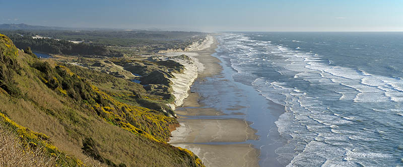
![OR: South Coast Region, Lane County, Pacific Coast, Oregon Dunes, North of Florence, The northern terminus of the Oregon Dunes, the largest dune field on Oregon's Pacific coast. The dunes impound a small lake. [Ask for #276.484.]](./imgstore/276.484.jpg) The northern terminus of the Oregon Dunes, the largest dune field on Oregon's Pacific coast. The dunes impound a small lake. [Ask for #276.484.] |
![OR: South Coast Region, Lane County, Pacific Coast, Cape Perpetua Area, Sea Lion Cliffs, Cliff view. The Sea Lion Caves attraction is visible in the distance. [Ask for #276.565.]](./imgstore/276.565.jpg) Cliff view towards the Sea Lion Caves attraction. [Ask for #276.565.] |
![OR: South Coast Region, Lane County, Pacific Coast, Cape Perpetua Area, Sea Lion Cliffs, View over the cliffs with gorse in full bloom [Ask for #276.490.]](./imgstore/276.490.jpg) View over the Sea Lion cliffs with gorse in full bloom [Ask for #276.490.] |
![OR: South Coast Region, Lane County, Pacific Coast, Cape Perpetua Area, Sea Lion Cliffs, Cliff view. The Sea Lion Caves attraction is visible in the distance. [Ask for #276.562.]](./imgstore/276.562.jpg) Sea Lion Cliffs, Cliff view. The Sea Lion Caves attraction is visible in the distance. [Ask for #276.562.] |
|
| |
Exploring the Pacific Coast
e-mail: jim@blogPacifica.com