Visting The Elliott: Links with the Outside
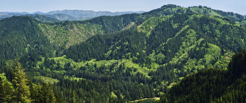
![OR: South Coast Region, Coos County, Coast Range, Elliott State Forest, Southwestern Quadrant, Rough gravel road climbs through a handsome young forest. [Ask for #274.471.]](./imgstore/274.471.jpg) This final Elliott State Forest page surveys the roads which link the Elliott with the outside world. As usual I have inspected all of these myself in an ordinary family vehicle (a 2004 minivan) and have included only the ones that a reasonably experienced driver (unfazed by gravel surfaces, cliffs, and steep gradients) could handle — no need for high clearance or four-wheel drive. Roads that show no sign of regular maintenance (like the one on the right) are omitted. I should note that I haven't yet inspected three additional connectors and so have left them off the map.
This final Elliott State Forest page surveys the roads which link the Elliott with the outside world. As usual I have inspected all of these myself in an ordinary family vehicle (a 2004 minivan) and have included only the ones that a reasonably experienced driver (unfazed by gravel surfaces, cliffs, and steep gradients) could handle — no need for high clearance or four-wheel drive. Roads that show no sign of regular maintenance (like the one on the right) are omitted. I should note that I haven't yet inspected three additional connectors and so have left them off the map.
A map at the bottom of this page shows these roads and their approaches.
|
SFR 3000This is the handsomest of the connectors with lots of old forest and wide views, as well as the most convenient to Coos Bay. To find it go north on US 101 from Coos Bay, cross the spectacular McCullough Bridge, and take the second right onto North Bay Road. Go 2.3 miles to a right onto Larson Way, a paved county road, then go 3.8 miles to a right onto gravel SFR 3000. This immediately enters the state forest and becomes a good, wide gravel road that climbs steeply upward along a stream. It tops out in 3.0 miles to follow ridgelines the rest of the way in. Look for a great view over the Pacific Ocean to your left very near its terminus, 7.7 miles from where it entered the forest. |
![OR: South Coast Region, Coos County, Coast Range, Elliott State Forest, Outside Links, FR 3000, Good gravel road gives access to this actively logged state forest, here running though fir forests [Ask for #274.159.]](./imgstore/274.159.jpg) SFR 3000 ascends to the ridgeline through fir forests. [Ask for #274.159.] |
![OR: South Coast Region, Coos County, Coast Range, Elliott State Forest, Southwestern Quadrant, FR 3000, Good gravel road gives access to this actively logged state forest, here giving a wide view from a replanted clear cut [Ask for #274.166.]](./imgstore/274.166.jpg) Here SFR 3000 gives a wide view south over the settled lands around the lower reaches of the West Fork Millicoma River [Ask for #274.166.] |
![OR: South Coast Region, Coos County, Coast Range, Elliott State Forest, The Ridgetop Drive, FR 2000, Good gravel road gives access to this actively logged state forest; view east from Trail Butte towards the Pacific Ocean and Oregon Dunes Nat Rec Area [Ask for #274.154.]](./imgstore/274.154.jpg) This roadside outcrop marks the point where there's a wide view east from SFR 3000 towards the Pacific Ocean and Oregon Dunes Nat Rec Area [Ask for #274.154.] |
![OR: South Coast Region, Coos County, Coastal Range, Elliot State Forest, Dean Mountain Area, Panoramic view towards Oregon Dunes NRA and the Pacific Ocean, from Dean Mountain Road at Trail Butte. [Ask for #274.158.]](./imgstore/274.158.jpg) |
|
SFR 4000This good quality (although narrow) link road starts at the village of Lakeside; to get there take US 101 from the McCullough Bridge on the north end of Coos Bay for 10.6 miles to a right onto Airport Way, then go 0.6 miles to the T-intersection, then go one long block to the center of town. From Lakeside take North Lake Road left (east) for 4.3 miles to the end of the pavement; the right fork is SFR 4000. From here it's 7.8 miles of good but narrow gravel road through young forest. The first mile or two was sold to a logging company in 2014. |
![OR: South Coast Region, Coos County, Coast Range, Elliott State Forest, Northwestern Quadrant, FR 4000, This logging road links the state forest with the town of Lakeside [Ask for #274.619.]](./imgstore/274.619.jpg) A typical stretch of SFR 4000, not far east of the recently sold area. [Ask for #274.619.] |
![OR: South Coast Region, Coos County, Coast Range, Elliott State Forest, Outside Links, FR 4000, A side road leads off into the forest [Ask for #274.620.]](./imgstore/274.620.jpg) An old track leads into the forests along the road. [Ask for #274.620.] |
Umpcoos Rd? SFR 5000?I mark this one "Unnamed Road" on my map as the latest official map doesn't show it, much less name it, but Google calls it "Umpcoos Rd" and Mapnik calls it "5000 Rd". It's an excellent gravel road, full width, with active logging projects along it. To find it take State Highway 38 east of Reedsport for 2.2 miles to a right turn onto paved Scholfield Rd, then go 3.1 miles to a right turn onto narrow gravel Scholfield Ridge Rd., an attractive little farm track. The state forest road starts 2.2 miles further on, a right turn over a creek. |
![OR: South Coast Region, Douglas County, Pacific Coast, Reedsport Area, Umpqua River Scenic Corridor (SR 38), Schofield Creek-Willard Area, Old traditional farm house [Ask for #274.520.]](./imgstore/274.520.jpg) This farmhouse marks the beginning of this link road at the point where it meets Scholfield Ridge Road. [Ask for #274.520.] |
![OR: South Coast Region, Douglas County, Coast Range, Elliott State Forest, The Ridgetop Drive, FR 7000, Signs indicate the intersection of SFR 7000 and SFR 2000 in a clearcut. View over a stack of cleared snags. [Ask for #274.A72.]](./imgstore/274.A72.jpg) This link road passes by several active logging areas, including this one at its eastern terminus. [Ask for #274.A72.] |
SFR 2000While most of SFR 2000 makes up the end of the Ridgetop Drive, its northernmost section leaves the ridgeline to drop down to State Highway 38 and the Umpqua River. The road quality isn't very good (the photos show you what it's like) but it makes up for it by passing through some of the oldest forests in the Elliott, forests that haven't been cut since the devastating 1868 fire. To find it take OR 38 east of Reedsport for 5.8 miles to a right onto paved Deans Creek Road, then take this straight ahead to the end of the pavement in 2.6 miles. SFR 2000 forks off to the right, uphill and into the forest. |
![OR: South Coast Region, Douglas County, Coast Range, Elliott State Forest, Outside Links, FR 2000, This mainline logging road passes through rock cuts as it descends to SR 38 and the Umpqua River. [Ask for #274.627.]](./imgstore/274.627.jpg) This is what SFR 2000 looks like as it climbs up to the ridge. You might want to take it slow. [Ask for #274.627.] |
![OR: South Coast Region, Douglas County, Coast Range, Elliott State Forest, Outside Links, FR 2000, This mainline logging road passes through a young hardwood forest on a steep slope. [Ask for #274.626.]](./imgstore/274.626.jpg) The road passes through a grove of red alders, the most common hardwood in the Coast Range. Note the grass growing in the middle, a sign of light use and little maintenance. [Ask for #274.626.] |
![OR: South Coast Region, Douglas County, Coast Range, Elliott State Forest, Outside Links, FR 2000, A Douglas fir forest on a steep slope, from FR 2000. [Ask for #274.623.]](./imgstore/274.623.jpg) Looking straight out through an old fir forest. [Ask for #274.623.] |
SFR 7700This leg, just 2.2 miles long, manages to climb 1,400 feet for an average gradient of 12%, the steepest you'll find in these pages. It starts just north of Loon Lake and joins the Ridgetop Drive at Cougar Pass. To find it, take OR 38 east from Reedsport for 13.1 miles to a right turn onto Loon Lake Road (which emerges impressively from a rock-bound canyon), then go 5.9 miles to a right, steeply uphill, onto SFR 7700. It will remain narrow as it switchbacks up the mountainside to crest out above a large sandstone cliff at 1.6 miles. Here it levels and follows the top of a new clearcut that gives numerous panoramic views for the next 0.75 miles. You'll meet the Ridgetop Drive (SFR 7000) about a half-mile along the clearcut. You'll have noticed the historic Cougar Pass Fire Tower on the ridge crest to your left; the gated track to the fire tower (a quarter-mile walk) is to your left down FSR 7000 a short distance. |
![OR: South Coast Region, Douglas County, Coast Range, Elliott State Forest, Northeast Quadrant, Cougar Pass Area, Cliffs emerge from fir forests as viewed from Cougar Pass [Ask for #274.505.]](./imgstore/274.505.jpg) The road reaches the ridgeline at these cliffs. [Ask for #274.505.] |
![OR: South Coast Region, Douglas County, Coast Range, Elliott State Forest, The Ridgetop Drive, Cougar Pass Area, View northward across the Umpqua Valley shows red cliffs [Ask for #274.498.]](./imgstore/274.498.jpg) The roadside view northward across the Umpqua Valley shows more red cliffs [Ask for #274.498.] |
![OR: South Coast Region, Douglas County, Coast Range, Elliott State Forest, The Ridgetop Drive, Cougar Pass Area, Wide views over clear cuts from FS 7000 (the northern mainline) at Cougar Pass [Ask for #274.509.]](./imgstore/274.509.jpg) Another view from the long clearcut at the western end of the road. [Ask for #274.509.] |
![OR: South Coast Region, Douglas County, Coastal Range, Elliott State Forest, Northeast Quadrant, Cougar Pass Area, Wide views over clear cuts from FS 7000 (the northern mainline) at Cougar Pass [Ask for #274.513.]](./imgstore/274.513.jpg) |
|
SFR 1850 (Loon Lake Road)From the 1930s to the 1950s Loon Lake Road ran south, marked as a state highway, to pass through Allegany and eventually reach Coos Bay. In 1957, however, a landslide wiped out its most remote section and was never rebuilt. Somewhere along the line Weyerhaeuser gained control of the ruinous road and the old right-of-way is now off limits. Today Loon Lake Road swerves into the Elliott, becoming SFR 1850.To find it proceed as with SFR 7700 (above), but keep going to the end of paved Loon Lake Road, a total of 13.5 miles from its intersection with OR 38. Go right over the bridge onto gravel SFR 1850. This will continue as a very high quality gravel road for the next 4.2 miles, intersection with the Ridgetop Drive (here FSR 1000). Scenery is unimpressive; the first 2.4 miles are on private land and is mainly clear cut. |
![OR: South Coast Region, Coos County, Coast Range, Elliott State Forest, Outside Links, FR 1850, This side road descends the mountain to Loon Lake [Ask for #274.496.]](./imgstore/274.496.jpg) Most of FSR 1850 passes through clear cut private lands, such as this stretch. [Ask for #274.496.] |
![OR: South Coast Region, Coos County, Coast Range, Elliott State Forest, Roads of the Elliott State Forest, in the Coast Range between Coos Bay and Reedsport. [Ask for #990.129.]](./imgstore/990.129.png) |
|
|
| |
BlogPacifica.Com
Exploring the Pacific Coast
e-mail: jim@blogPacifica.com
Exploring the Pacific Coast
e-mail: jim@blogPacifica.com
Copyright ©2023, James A Hargan. All rights reserved.
All maps created using data from DeLorme Topo North America® v9.0, ©2010 DeLorme®
(www.deLorme.com)
Contact the webmaster at
maven@harganonline.com